
Photo album from Jean’s trip to the Ross Sea, Antarctica. A small selection of my best photos, with descriptions, are here. Click on a photo to see it larger.
Words are not going to do justice to this trip. I can tell you some of what happened, but it really was a “you’ve got to be there” experience.
As with many expeditions to unpredictable parts of the world, many things did not happen according to the itinerary. Some of the differences were unwelcome (though not entirely unexpected), but others created a better experience than expected.
The trip began in Bluff, New Zealand, on January 21. I had flown from Townsville to Sydney on the 19th, overnighted there in a hotel near the airport, then flown via to Invercargill, where I overnighted on the 20th. That afternoon was windy and cold, so I was glad that my motel was next door to a convenience store and only a block from a liquor store. Wine, cheese, and crackers did well as an evening snack.
The ship (Orion) had organised staff to meet passengers at the Invercargill Visitors’ Centre, from where buses took us to Bluff. On board, we went through immigration formalities and were shown to our cabins. However, we did not depart that afternoon as intended, but instead stayed overnight at the wharf.
The delayed departure was due to bad weather in the Southern Ocean. By leaving 12 hours later, we allowed a storm front to clear from our path, so we could try to slip south between it and another storm front and get far enough south quickly enough to avoid the worst of the weather. We were successful, though the rough seas caused some passengers to be quite seasick during the first several days. I didn’t get seasick, but I did take tablets and spent a lot of time lying down in my cabin. Hence I didn’t see as many of the albatross and other seabirds, nor any of the dolphins and whales, that more hardy travelers witnessed.
The expedition’s leaders decided to skip planned stops at several subantarctic islands on the way south (where the rough seas would have prevented landings anyway) and head directly to the Ross Sea. So we had a week of nothing but ocean, birds, and animals, punctuated by lectures on a variety of topics: history, natural history, our leaders’ personal experiences, oceanography and weather, photography…
All of the expedition team were interesting, enjoyable to talk with, and gave great talks in their areas of expertise. I’ll only mention a few. (The crew—mainly Filipino—were great fun, too, as well as being helpful and competent.)
The expedition leaders, Don and Margie McIntyre, are well known (at least in Australia) for having spent a year living in a box the size of a shipping container, chained to the rocks near Mawson’s Hut. They gave a talk and showed a documentary about their experience. (Don is also known for his many other adventures.)
The assistant leader was Diana Patterson, the first woman to lead an Antarctic research station (Mawson Station, 13 months from late 1989). She’s also done many interesting and adventurous things. I very much enjoyed talking with her and listening to her lectures.
One of the lecturers/entertainers was Dr Karl Kruszelnicki, well known in Australia for his Science Talkback show on Triple J. He’s quite a character, and knowledgeable on an impressive range of topics
Each evening, and some afternoons, musical entertainment was provided; afternoon tea (with cakes and sandwiches) was followed by team trivia. I don’t enjoy these activities, so I skipped them. I was also avoiding drinking any alcohol, because of the anti-seasick tablets.
Each evening, just before dinner, a briefing was presented in the lounge, with a summary of the day’s events, the plans for the next day, the weather report, and a reading from Scott’s journal of events that occurred exactly 100 years ago each day… only a few weeks before Scott’s party perished on their return from the South Pole.
On 25 January, we crossed 60 degrees South and held the traditional “crossing the line” ceremony, which consisted of those who’ve never been that far south (55 of us) being sprayed with ice cold salt water from the fire hose. Most of us wore swimwear; a few wore shorts and t-shirts. Don McIntryre, wearing full cold/wet weather gear, sported an evil grin as he sprayed us. Survivors were welcomed back into the lounge with towels, bathrobes, and hot chocolate. Later we received a certificate, and I have a video (taken by Dr Karl) of the ceremony.
Around the same time we crossed the Antarctic Convergence, which is the zone where the cold, northward-flowing Antarctic waters meet and mix with the warmer waters of the sub-Antarctic.The cold water mainly sinks beneath the warmer water, but the mixing creates a zone of high productivity, especially of krill.
Bets were laid for the first sighting of an iceberg (must be at least the size of a typical 3-bedroom suburban house; little chunks didn’t count), and hardy souls spent a lot of time on deck watching for whales and dolphins as well. The first iceberg turned up on the 26th, well ahead of other ice, but soon more—of all sizes—began appearing. By early morning on the 27th, the ship was surrounded by bergs: some the size of small cities, some of fanciful shapes, some with penguins or seals riding on them.
Later in the voyage we were to visit Scott’s and Shackleton’s huts, and several of the expedition staff were from the New Zealand Antarctic Heritage Society (these two huts are in the NZ Antarctic Territory). The question, of course, was whether we would get there.
Part of the daily weather report was the ice report, featuring satellite photos and ice maps derived from satellite data. There was a wide (100 nm or more) band of floating “pack ice” between us and the Ross Sea, and other bands of ice moving along the western and southern parts of the area we were headed for. Would they be in our way when we got there? Would we be able to get through the ice if it was there? The previous expedition, to a slightly different part of the continent (Commonwealth Bay, where Mawson’s Hut is located) could not get through and had to turn back.
So… we got to the band of pack ice and started through the narrowest section. It was suitably awesome to view, but no fun for the Ice Pilot (a specialist) to navigate, even with other crew spending cold 2-hour watches in the crow’s nest, looking for the best way through. The late evening (11:00pm) and early morning (3am or earlier) light on the ice was beautiful.
Meanwhile we were watching for auroras as well. Those who were awake and watching did see some, but the cloud cover made visibility difficult. This was a real pity, since a solar disturbance was causing ideal conditions for auroras to form.
Eventually we made it through the pack ice and into calm seas. But again we had to forgo one of the planned landings (Cape Adare), because it looked ice-locked on the satellite photos and a diversion to check on it might delay our dash to the far South long enough for ice to move around and get in our way there too… so the decision was made to press southward and hope we might be able to land at Cape Adare on the way back. By now we were into 24-hour daylight.
As we got closer to our destination, Ross Island (where Mount Erebus and Scott’s and Shackleton’s huts are located), the weather turned mainly clear and beautiful. We stopped at Frankland Island for a look at the penguins, then pressed on to the edge of the ice shelf (78.4º S), from where we could see the Russian icebreaker that keeps a channel open to the US base at McMurdo. Most people then visited Scott’s Hut at Cape Evans. As we were arriving, a group of conserva-tors were leaving after several weeks of work. Later we continued north a few kilometres to Shackleton’s Hut, also being conserved.
Then we began the long trek back to New Zealand. Back through the pack ice, back into the rough waters of the Southern Ocean, and then a dash to Macquarie Island. We were unable to land Zodiacs due to the rough seas, but we got a good look from the ship and a visit from some of the people from the research station, who gave us a talk on their activities including their part in the rabbit eradication program.
On north to Enderby Island, where people were able to land and view penguins and elephant seals, and then to Snares Island, where again it was too rough for a landing. And finally, back to Bluff.
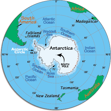
Note the location of NZ, 60º South, and the Antarctic Circle (66.33º South)
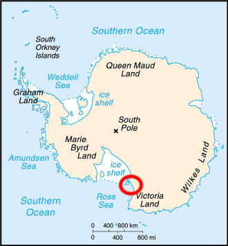
Notice that most of the Ross Sea is covered by an ice shelf. We went to the area marked by the circle.