Cape York Trip, September 1996
In September 1996 I took a 15-day 4WD camping tour of the Cape York Peninsula of Australia. For a map of the route we took, click here.
The trip started in Cairns, early on Saturday, 31 August. I flew to Cairns a couple days before, because I wanted to do some other things while I was there.
The flight from Sydney arrived in mid-afternoon, and I took a taxi to my hotel, the Great Northern, a pleasant bed-and-breakfast place only a couple of blocks from the new casino. It was also only a block from the cheap (but good) eateries Eric and I had found on our previous trip a few years before.
After dropping off my bags, I set out to the wharf, to organise a visit to the Tjapukai Aboriginal Culture Park for Friday, then wandered about re-acquainting myself with the shops and arcades. I do enjoy that part of Cairns.
Tjapukai
Tjapukai is quite impressive. The local Aboriginal people had developed a very successful dance theatre in a town on the Atherton Tablelands above Cairns, and only in July 1996 had moved to a new "culture park" which they had built a few miles from the city, next to the lower terminus of the Skyway that takes people on a skilift-gondola up the mountainside.
This group has put considerable effort into preserving and reviving their cultural heritage, language, and so on. The culture park features 2 indoor theatres, an outdoor dance stage, and small shelters featuring bush foods, didgeridoo making, spear and boomerang throwing, etc. The outdoor stuff was fairly standard, though well-done tourist stuff, but I was most impressed with the indoor theatres.
One theatre showed a film of the impact of white immigration on the local indigenous people. It was partly taken from old still photos and partly done in reenactment.
In the second theatre, two narrators (a man and a woman) told the group's dreamtime story, while others reenacted parts of it onstage. The impressive part was the laser and hologram show that was interwoven with the acting.
The narration in both theatres was in the group's own language. Earphones provided translations in a choice of 6 or more European and other languages.
After watching the outdoor dancing, I chatted for while with some of the dancers (all teenagers or young adults), then munched an emuburger with various condiments and wandered off to the didgeridoo demonstration. After explaining how to find a suitable tree and clean it out, the demonstrator said, "if you live in the city and can't get out to find yourself a tree, just go down to the hardware store and pick up a length of PVC pipe" (the stuff that's used for kitchen or bathroom plumbing). He then pulled out this 2-metre length of white plastic pipe and proceeded to play it. It sounded not all that different from the "real thing". Cracked me up.
Visit the Tjapukai web site for more information, photos, and links.
That evening, back in town, I discovered that a restaurant I'd previously avoided because of its cost had a special if you ate before 6 PM: 30% off your food bill. Since I normally prefer to eat early anyway, I popped in and had a delicious dinner of "bugs" (a type of crayfish).
The trip begins
I was picked up by the tour driver at 7:15 AM outside the hotel. There were only five passengers on the tour, plus the driver, in a Toyota LandCruiser that seats eight people. A couple from Melbourne (mid-30's in age), a computer jock (50-ish) from Wollongong, and a young Swiss woman, who was 4 months into a 6-month tour of Australia. She only went one way, being replaced by a 45-year-old builder from Gosford.
After picking up the passengers, the driver collected the trailer with food supplies, tents and other camping gear and we set off up the highway to the Atherton Tablelands. We stopped at Split Rock to look at some Aboriginal rock paintings (in reasonably good condition), then on to the Quinkan pub for a drink. This old place has a row of huge mango trees out front, with tables and chairs in the shade beneath. Quite pleasant.
Then on to Mary Valley for our first night's camp, outside a private homestead. Like many of the houses in this tropical country, most of it has no walls, only thick posts holding up a tin roof over a concrete floor. The kitchen is delineated by half-walls of cupboards and appliances. The resident (white) family served us a huge, tasty (but rather overcooked) meal.
At dusk we could clearly see a huge colony of flying foxes (otherwise known as fruit bats) setting off for their night's foraging. In the morning, anyone up at dawn (as I tend to be) could see them returning to their roosts in the trees somewhere nearby.
The toilets and showers at this camp were in tin sheds, but there was hot water. I forget if there were electric lights in the facilities, but if so, they were turned off early (being run off a noisy generator). Many such damp shower areas are home to little green frogs; this one had small cane toads. Small cane toads are kinda cute, unlike the big ones.
We have individual tents, the igloo-shaped ones with the poles on the outside, quite easy to put up and take down. The insect screens do a good job against the mosquitoes as well as flies. We had dense foam mattresses, quite comfortable, to lie on. I had my own sleeping bag, but (as expected) I mostly slept on it, not in it, because of the warm nights.
Mary Valley was once a telegraph station on the line that ran up Cape York (now long superseded by wireless telecommunications). Its fences are constructed almost entirely of recycled steel telegraph poles.
On to Archer River
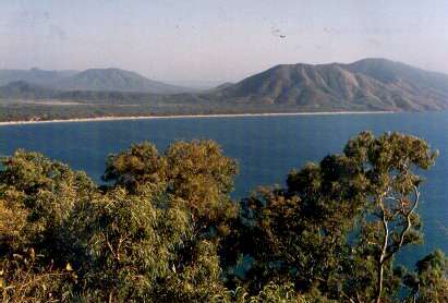
 Photo right: Coen. Sunday we drove through the bush to a river
where we did some crocodile-spotting (we saw lots of eyes and nostrils
sticking above the water, but no crocs out sunning themselves), and passed
through Musgrave (another former telegraph station, now a roadhouse and
camping spot with an airstrip), where we stopped for morning tea. At that
point I first began to realise that there is a lot of tourist traffic
on the Cape York road.
Photo right: Coen. Sunday we drove through the bush to a river
where we did some crocodile-spotting (we saw lots of eyes and nostrils
sticking above the water, but no crocs out sunning themselves), and passed
through Musgrave (another former telegraph station, now a roadhouse and
camping spot with an airstrip), where we stopped for morning tea. At that
point I first began to realise that there is a lot of tourist traffic
on the Cape York road.
We ate lunch at a pleasant spot on a riverbank near Coen, which is actually a small town. Photo below: Lunch spot near Coen.
 We swam in the river, which boasted a rope hanging from a tree over a
deep spot, so the adventurous could swing out, let go and plunge in. In
fact, we swam in almost every river we crossed, except a couple of very
muddy ones. Hot, sweaty driving (the air conditioning in the LandCruiser
didn't penetrate into the back real well) was punctuated with quick dips
in a river, then back into the vehicle dripping wet, where the evaporation
as our clothes dried helped to cool us off.
We swam in the river, which boasted a rope hanging from a tree over a
deep spot, so the adventurous could swing out, let go and plunge in. In
fact, we swam in almost every river we crossed, except a couple of very
muddy ones. Hot, sweaty driving (the air conditioning in the LandCruiser
didn't penetrate into the back real well) was punctuated with quick dips
in a river, then back into the vehicle dripping wet, where the evaporation
as our clothes dried helped to cool us off.
Overnight was at Archer River, which has a roadhouse, some motel rooms, and a large camping area. The river was quite low at that time of year, so one had to walk a ways down the road to get to the water.
Broken radiator
Monday's excitement was a broken radiator. We had passed the turnoff to Weipa (a large mine on the west coast of the Cape) and the turnoff for the road that bypassed the worst of the old Overland Telegraph Road, and had continued up the old road.
At my request, we had stopped to take some photos. At that point, by coincidence (though I got teased about it for days) the radiator sprang a major leak and water poured out. After wandering about inspecting termite mounds and various plant life, we sat in the shade of the trailer (there wasn't much in the way of natural shade at that point) and waited for the radiator to cool down enough for the driver to attempt to fix it. Which he eventually did.
Then we discovered (to the passengers' disgust) that the vehicle wasn't carrying enough spare water to fill the radiator again. So out came the ice from the coolers, and all our drinking water, ready to be put into the radiator. Fortunately about this time another tour vehicle -- only the third vehicle we'd seen in two hours (so much for lots of traffic; everybody else must have taken the bypass road) -- came along and gave us some water.
 Photo right: Crossing Gunshot Creek.
Only a few kilometers further
on we crossed a river and were able to fill up every available container
with water. Soon we reached some of the famous river crossings, including
Gunshot Creek.
Photo right: Crossing Gunshot Creek.
Only a few kilometers further
on we crossed a river and were able to fill up every available container
with water. Soon we reached some of the famous river crossings, including
Gunshot Creek.
It's not that the old road is so bad (though there are places one could bog down in the sand), but it makes some quite dramatic river crossings, going down and up steep, muddy banks and fording the water. Many vehicles have to be winched out of the mud. In September the water level was low, but some of the banks were pretty chewed up.
 Photo left: Elliot Falls. We got through okay and arrived at our
intended camp at Elliot Falls just before sundown and had time for a dip
in the delightful river before it got too dark.
Photo left: Elliot Falls. We got through okay and arrived at our
intended camp at Elliot Falls just before sundown and had time for a dip
in the delightful river before it got too dark.
A bit of juvenile humour on the road: because it followed the natural contours of the land, there were a lot of "dips", each carefully marked with a sign. Many of these signs had been altered to read "onion dip", "salmon dip", "skinny dip", "sheep dip" and so on. The driver declined to stop to let us add our own witticisms to the unmarked signs.
We cross the Jardine
 Photo right: Crossing the Jardine River. The Jardine River is the
last big river before the tip of the Cape. It used to be a major problem
for tourists, as it is deeper and wider than the other rivers and often
could not be crossed at all, or only with considerable difficulty.
Photo right: Crossing the Jardine River. The Jardine River is the
last big river before the tip of the Cape. It used to be a major problem
for tourists, as it is deeper and wider than the other rivers and often
could not be crossed at all, or only with considerable difficulty.
These days there is a ferry. North of the Jardine is Aboriginal land, which one must have a permit to enter. The permit includes the cost of the ferry crossing (both ways).
 Photo right: Campsite at Umagico. On Tuesday we crossed the river
and went on through the town of Bamaga
(inhabited mostly by the descendants
of Torres Straits Islanders displaced to the mainland during WWII) to
our campsite on the beach at Umagico on the western side of the Cape.
Photo right: Campsite at Umagico. On Tuesday we crossed the river
and went on through the town of Bamaga
(inhabited mostly by the descendants
of Torres Straits Islanders displaced to the mainland during WWII) to
our campsite on the beach at Umagico on the western side of the Cape.
After a relaxed afternoon (and much laundry-washing), we went out on a fishing boat for a cruise around some nearby islands. I turned a bit green, being out of practice at this. We also didn't catch any fish, and the driver burnt the dinner we did cook. Not the best day. Later everybody except Yvonne and me went into town to the Aboriginal "canteen" (pub) for a bit of carousing.
I make it to the tip
 Photo right: Jean standing at the
tip of Cape York Peninsula. On Wednesday we drove as close as one
can get to the tip of Cape York, then walked about a kilometre over rocky,
uneven ground (and up and down rocky hills) to the tip itself. My right
knee had been giving me trouble all trip, and on this hike I wasn't sure
I was going to make it back, but I did. The track provided some spectacular
views, and the rocky tip itself is pretty impressive.
Photo right: Jean standing at the
tip of Cape York Peninsula. On Wednesday we drove as close as one
can get to the tip of Cape York, then walked about a kilometre over rocky,
uneven ground (and up and down rocky hills) to the tip itself. My right
knee had been giving me trouble all trip, and on this hike I wasn't sure
I was going to make it back, but I did. The track provided some spectacular
views, and the rocky tip itself is pretty impressive.
We then drove to Somerset, once a provincial (white) government centre, abandoned after too many raids by Aborigines; one of the few times the indigenous people won. The government centre was moved to Thursday Island, where it remains today.
There's a nice beach there, with some rock carvings some distance down past a lot of mangrove and rocks. My knee wasn't up to climbing over rocks, so I sat in the shade of the mangroves and read a book while the others made the trek.
Thursday Island
I'm not sure if this was a coincidence or not, but on Thursday we visited Thursday Island. We took a bus tour of the historic sites, including some impressive anti-aircraft gun emplacements from WWII. TI (as it's called) has a hospital and other government facilities, mainly to cater for the Torres Strait islands that are part of Australia. The views of other islands from the heights are excellent.
The airstrip for TI is actually on another island (Horn), and one must take a ferry from one to the other. Our driver left us here and was replaced by Gary, the tour company's owner, who would be our driver on the way back to Cairns.
Bush camping
After another leisurely morning on the beach, we set off, stopping at the wreck of a WWII DC3 (which had missed the runway when attempting to land), then turning off the road to go on a very sandy track out to a camping spot near the mouth of the Jardine River.
 Photo right: Bush camp near mouth of Jardine River. The river is
quite wide and shallow at this point, and we were warned not to swim except
when the tide was running strongly out, and then only if someone was watching,
because of the threat of saltwater crocodiles.
Photo right: Bush camp near mouth of Jardine River. The river is
quite wide and shallow at this point, and we were warned not to swim except
when the tide was running strongly out, and then only if someone was watching,
because of the threat of saltwater crocodiles.
My notes say that Gary believes in more vegetables with meals than our first driver did. As a person who likes more than potatoes with my meat, I appreciated this.
Fishing and other sports
On Saturday the blokes went barramundi fishing in a hired boat. They didn't catch any barra, but they came back with more of some tasty fish than we could all eat. Chris and I decided to walk along the beach and generally goof off.
We were camped on both sides of a track that led to other campsites, strung out along the (sand) cliff top, so we tended to get some traffic during the early and late parts of the day. Everybody passing through would stop and exchange news about good fishing spots, places to avoid on the track because of the probability of getting bogged in the sand, mechanical problems with vehicles, and so on.
This spot, being a bush camp, had no showers and only pit toilets. So we washed in the river and kept an eye out for crocodiles.
More radiator trouble
We were up and on the road early, stopping at another WWII site on the coast, which had concrete bunkers (the anti-aircraft guns long since removed), a large radar installation (much rusted), the pilings of a long pier, and a cleared area where supplies were landed.
The whole Cape is full of old war relics, and many of the communities are linked to the rest of the world by boat, 4WD over a long dirt track, and an airstrip.
We then headed south, crossing the Jardine at the ferry. A few kilometres further on, the radiator warning light came on and we discovered that the hole had opened up again. (I earlier left out a long boring bit about the alleged repair of this thing while we tourists were on Thursday Island, and the decision not to fly in a replacement radiator.)
We had enough water this time to refill it, but Gary decided to turn back to Bamaga for repairs, as that town was a lot closer than the next place south which could do that sort of work. This was a slow, tedious trip, involving stops every few km to pour more water into the radiator.
This time we camped at a less pleasant (and more crowded) campground in the town of Seisia, near the Thursday Island ferry wharf. We shared a kitchen shelter with a young man from New Zealand who had ridden a bicycle from Cairns (he was taking the boat back). We shared our leftover food with him, to his obvious delight. He was especially happy to get fresh salad, since he couldn't carry much except dried food with him. A day or so later we met another New Zealander on a bicycle and gave him some food too.
Driving down the river bed
Monday, 9 September. We left Bamaga around noon, after fixing the vehicle and doing some shopping (mainly replenishing the beer supply). Back across the Jardine River ferry. Stopped at Fruit Bat Falls for a refreshing dip in the river. When we reached Bertie Creek, the driver turned right and drove up the creek bed for about a kilometre to a secluded camping spot. The river bed was stone, and surprisingly smooth. The water level was well up the wheels but didn't flood into the passenger section.
We haven't seen much wildlife on this trip, even at dawn and dusk when one might spot the occasional kangaroo. There's been some birds, though not a great variety.
Back to Archer River
 Photo right: One of the better stretches of road. Tuesday, 10 September.
Because of losing a day getting the radiator fixed (or replaced; I'm not
sure which), we skipped a side trip to the mining town of Weipa. I didn't
mind this at all. I had expected us to take the bypass road past the difficult
river crossings, but we went down the old road again. Possibly this was
for the new passenger's benefit, as he hadn't been on the trip up. Whatever
the reason, I didn't mind this either.
Photo right: One of the better stretches of road. Tuesday, 10 September.
Because of losing a day getting the radiator fixed (or replaced; I'm not
sure which), we skipped a side trip to the mining town of Weipa. I didn't
mind this at all. I had expected us to take the bypass road past the difficult
river crossings, but we went down the old road again. Possibly this was
for the new passenger's benefit, as he hadn't been on the trip up. Whatever
the reason, I didn't mind this either.
We ate lunch by the Wenlock River, then went on to Archer River for the night.
Lakefield National Park
 Lakefield National Park. Wednesday, 11 September. Back through
Coen and Musgrave, then off to the east into Lakefield National Park,
which was formed from 3 cattle stations: Bizant, Laura and Lakefield.
We stopped at several lagoons to look at birds, and saw wallabies, emus
and a dingo pup. This area is much less dry than the rest of the Cape
at this season, and was the only spot where we saw much bird or mammal
life. We camped somewhere in the park.
Lakefield National Park. Wednesday, 11 September. Back through
Coen and Musgrave, then off to the east into Lakefield National Park,
which was formed from 3 cattle stations: Bizant, Laura and Lakefield.
We stopped at several lagoons to look at birds, and saw wallabies, emus
and a dingo pup. This area is much less dry than the rest of the Cape
at this season, and was the only spot where we saw much bird or mammal
life. We camped somewhere in the park.
Jowalbinna
Thursday, 12 September. After a detour into Laura for more beer, a short drive took us to Jowalbinna Homestead, the home of Percy Trezise, a well-known artist. He was in Cairns that day, receiving an Order of Australia award, so we missed meeting him in person.
His home is quite impressive. The peaked corrugated-metal roof is held up by tall timer posts the thickness of telephone poles. The exterior walls are made up mainly of louvers which can be opened to let in every bit of breeze, and they don't quite meet the roof, which overhangs them to form wide verandahs on all sides. The only interior walls are around the bathroom. Other "walls" are either curtains or various pieces of furniture that delineate "rooms". Gives a whole new meaning to the term "open plan". It's very practical for the climate, but it must be rather exciting in a cyclone. And utterly without security, obviously not a concern. (Another artist, Mary, was in residence, keeping an eye on the place and on a dingo bitch with pups.)
 Aboriginal rock art at Jowalbinna. We camped a few kilometres down
the road at a camping area run by Percy's son Steve, who led us on an
exhausting walk up a steep escarpment to view some excellent examples
of Quinkan Aboriginal rock paintings.
The views from the trail were impressive, too.
My knee again almost gave out completely on me, and I would have
really slowed down the others, had anybody except our guide bothered to
pay any attention.
Aboriginal rock art at Jowalbinna. We camped a few kilometres down
the road at a camping area run by Percy's son Steve, who led us on an
exhausting walk up a steep escarpment to view some excellent examples
of Quinkan Aboriginal rock paintings.
The views from the trail were impressive, too.
My knee again almost gave out completely on me, and I would have
really slowed down the others, had anybody except our guide bothered to
pay any attention.
Cooktown
Friday, 13 September. Drove to Cooktown, diverting to The Red Lion Inn, a leftover from the Palmer River Gold Rush last century.
Cooktown is a reasonably-sized town, which has suffered from lack of tourism due to the difficulty of getting there (only recently has the road become passable for non-4WD vehicles, though it's also accessible by sea and air). (1999 update: a new, paved road is under construction.)
 Endeavour River
seen from lookout at Cooktown.
Cooktown is a beautiful spot, and the view from a high hill in town, looking
over the winding Endeavour River, is impressive.
Endeavour River
seen from lookout at Cooktown.
Cooktown is a beautiful spot, and the view from a high hill in town, looking
over the winding Endeavour River, is impressive.
We dressed up to eat in the town's best restaurant (at the Sovereign Hotel), and had a delicious seafood meal. Most of the others went pub-crawling afterwards, but I went back to the campground and turned in early.
The Bloomfield Track
Saturday, 14 September. Leaving Cooktown, we headed south along the coast past Bloomfield, then down the infamous Bloomfield Track to Cape Tribulation. The Track was strongly opposed by conservationists in the mid-80s, with people chaining themselves to trees, lying in front of bulldozers, and getting lots of media coverage. They eventually lost the battle and the road went through. It's a bit of a mess, with the dust from the road coating all the visible vegetation in some spots, but how much damage has been caused beyond the obvious, I don't know.
From Cape Tribulation on south, the road is generally passable by ordinary vehicles, having been significantly upgraded around the same time that the track went in. Hence Cape Trib is over-run with tourists. It's a beautiful spot, and has a well-designed educational boardwalk through the mangroves. Then across the Daintree River on the ferry, a quick rip around Port Douglas (the old part of which I really like), and on down the beautiful coast and back to Cairns.
Cairns Casino
Sunday, 15 September. I had been unable to get a seat on a flight before late afternoon, so I had plenty of time after checking out of the hotel to wander around some more. I discovered that the Cairns Casino was having an Open Day, in an attempt to lure some of the local citizens into gambling, I assume.
So I wandered along, in the interests of comparing it to Las Vegas casinos. While there I took the opportunity to practice what I could remember of the blackjack lessons that a friend had given me, and I did quite well. This was, however, at the "practice" tables so I didn't actually win any money.
Then I looked around as much of the gaming floors as I could see, which was two levels. It was generally as gaudy as Vegas, but not as noisy as they didn't seem to have many customers. (The place is not doing at all well financially, I have since read.) I didn't see the "interior rainforest" that I'd seen in photos, so I assume that's on a higher level, that one is only allowed into if one is wagering rather more money than I ever would. An interesting note on which to end the trip, and quite a contrast to tent camping!
More about Cairns from Cairns Online.
Home | Newsletter | Places | Books/Music | Transport | Topics | About us | Index | Search
Brought to you by:
Eric Lindsay and Jean Weber
P.O. Box 640, Airlie Beach, Qld 4802, Australia
Contact us info@avalook.com.au
ABN 96 350 124 090
Page last updated 10 February 2004
![]()
![]()